Monday, December 17, 2012

Three Gorges Dam


Three Gorges Dam

What is the Three Gorges Dam? Why should we care about what it? These are some of the important questions to answer when talking about the world’s largest hydropower project.  The dam became fully functional on 4 July, 2012, and has cost a reported 24 billion dollars. It has the ability to produce an immense about of power, to be more precise 84.7 billion kW (unit of power equal to 1000 watts) annually. The dam is a massive 7,661 feet long, at the top, and it has a reservoir 410 mile reservoir.  It provides 20 million households electricity. To put it in context, the Three Gorges Dam is about five times larger than the Hoover Dam. This is incredible, especially if you have seen the immense size of the Hoover Dam.
Given what I have told you the Three Gorges Dam seems like a modern marvel. Not only does it help provide electricity for people, but it also helps prevent flooding. However, once you start looking at what had to happen to get the dam built and what toll it has had on the ecosystem in China things get interesting. . 

Displacement of people was the primary issue of those that opposed the dam’s approval in 1992. The construction of the dam displaced 1.5 to 4 million people. This is a large number. The people that were displaced had to leave lands that their families had occupied for years. Proper compensation was not usually given. Only a minority received enough to start a new life in a different area. Those that were not given enough were not even given help to relocate. The government sees the dam as a much needed tool for energy, and that it is a green source of energy. I, among other opposition, see it as a huge abuse of power that has led a substantial amount of people into poverty.

The dam has also been linked to something called reservoir-induced seismicity. Reservoir-induced seismicity becomes a problem when a dam is built on a fault line. The Three Gorges Dam sits on the Jiuwanxi and Zigui-Badong faults. These faults become strained because of the large amount of water on top of them. This strain creates earthquakes, which are usually small, but in some occasions can cause significant damage. Earthquakes generated by dams are nothing new. For example, California’s Oroville Dam, in the foothills of the Sierra Nevada has had the same issues. However, this dam is much smaller, so it creates much less earthquakes. The government was warned of this before construction began, but they did not listen. This shows complete negligence and because of it a large amount of people could die.

Animals and plants have been threatened because of the floods generated by the dam’s placement. This is an issue because China is the home to 10% of the worlds rooted plants (vascular plants). Of that 10% about 20% are located in the dam’s vicinity. This means that a large flood could destroy a great percentage of these plants. The dam has also hurt many natural environments because it has changed flow patterns. This means that areas that used to not get flooded are, and areas that are used to getting flooded are not. Animals and plants over time evolve to the areas they are in. This means that plants grow where they are going to benefit most from the area. Animals understand patterns and stay away from risk if risk is there. However, these changes catch plants and animals off guard and result in their death. The dam water is also highly polluted which has caused fish to start dying. Fish are very important to the people of China, and pollution has been an issue in that matter for some time. Solving these problems has been a goal for many villages and outside forces, but the government and large companies within China don’t see the problem.

There is a lot that needs to be done, and people are trying. The only issue is that most of the work being done is not by those that can actually do something. Until the government realizes that this project has severe consequences the issues will continue. Even if countries such as the United States and Germany try to pressure China they will not succeed. China sees this project as something beneficial, and the government will not lose face with its people by saying that it is wrong. This goes back to Chinese history, and the government’s constant need to show that it’s able. A solution might be possible, actually it is, but it is unlikely until the government becomes more concerned.


Thursday, December 13, 2012

Post:1 after class and going forward!

My Urban Environmental History class is over, but I have decided with a little guidance from my instructor to continue my research. I will still post on Iowa, but I will also incorporate other states, countries, environmental justice, and hopefully posts from other people, ones that have been through a flood personally. 

Reasons for new approach:

Other States: the 1000 year flood in Tennessee would be the main answer, but also Hurricanes suck as Sandy, Katrina, and Andrew

Countries: the documentary  "Flow" got me interested in water contamination due to dam creation.The Three Gorges Dam in China. It's construction caused 1.7 million people to lose their homes. The link on the dam will take you to Scientific American (link to the about us page for Scientific American), which is a web based science magazine. The title of the article is 

China's Three Gorges Dam: An Environmental Catastrophe? by: Mara Hvistendahl

From the title you might guess what the article will cover. I will try and review the article and get more information about the Three Gorges Dam on here tomorrow. I'd do it today but, I still have finals to write.

Other countries that interest me are Russia, England, the whole area ravaged by the 2004 Tsunami (this link will take you to a 8 part series on Youtube that show the Tsunami), then countries in Africa and South America

Environmental Justice: I want to do what flow did, but I want to do it with text. This might make more sense if you have watched the movie.

And last user input: I want post for people that have been in floods. They are the best suited to write on the subject since they have lived it.


Wednesday, December 12, 2012

Mississippi River

Great Flood of the Mississippi River, 1993

1993 Flood Programs

Flood Programs prior to 1993
  • Reservoirs and levees built by the Corps prevented more than $19 billion in potential damages.  
  •  Watershed projects built by the Soil Conservation Service saved an estimated additional  $400 million. 
  •  Land-use controls required by the National Flood Insurance Program and state floodplain management programs reduced the number of structures at risk throughout the Mississippi basin. 
  • Weather cooperated with a freeze late in the year, and spring 1994 saw only a few minor  floods. This allowed many repairs to be made. 

Flood Programs Implemented after 1993 
  • Created the Increased Cost of Compliance program within the NFIP (National Flood Insurance Program) for all people who  have a flood insurance policy. This program gives money to owners of substantially damaged properties to meet the more expensive costs of rebuilding according to a local  floodplain management ordinance. 
  • Created the Flood Mitigation Assistance program This program is funded from a surcharge added to all flood insurance policies nationwide. The money is then redistributed to states in the form of grants to be used to mitigate future flood losses.   
  •  Increased emphasis on floodplain mapping. 
  • Codified the Community Rating System (CRS) into the NFIP. The CRS is an incentive program which allows communities to reduce their costs for all flood insurance policies in exchange for going above and beyond minimum NFIP requirements. 
  • Under the Clinton Administration, FEMA targeted buyouts of flood-damaged properties as the first priority for Midwest flood mitigation funds. This initiative represented a turning point in flood recovery policy: it was the first time buyouts had been attempted on such a large scale. In the nine states that flooded, FEMA ultimately moved more than 300 homes, and bought and demolished nearly 12,000 at a cost of over $150 million. The lands were turned to flood-friendlier uses such as parks and wildlife habitat. State and federal agencies have also acquired interest in over 250,000 acres of flood-prone land. 
  • According to FEMA data, another 9,140 properties in 140 communities were elevated, acquired or relocated under hazard mitigation grants. Projects ranged in size from elevations of one or two homes in a neighborhood to entire communities moving to new locations.


http://www.dnr.ne.gov/floodplain/PDF_Files/FloodUpdateStory_Rev3.pdf

Devonian Fossil Gorge

Historic floods during the summer of 1993 poured over the emergency spillway at Coralville Lake and eroded a deep channel into the underlying bedrock deposits. It is now possible to walk across acres of Devonian-age sea floors and get a first-hand look at features normally hidden from view or glimpsed only in vertical cuts along roadsides or in quarries. The exposed rocks provide a rare opportunity for public observation of Iowa's past. 


By:Resourcesforlife
Uploaded on Mar 21, 2011
This is a short video about the Devonian Fossil Gorge near the Coralville, Iowa Reservoir.
  • Category

    Education
  • License

    Standard YouTube License


1993 Flood Overview


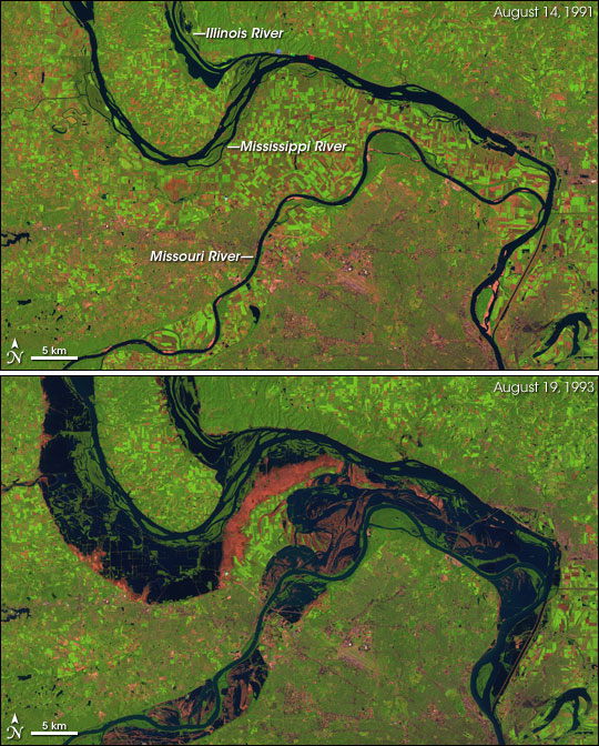
The start of this flood began in 1993, when above average rainfall persisted for months. This rainfall left the ground over saturated  which is perfect conditions for floods. Along with the saturated ground, the lack of sunlight helped create the flood. Without enough sunlight, the water that was already on the ground was unable to become evaporated. Finally, delayed uptake of water from plants also caused this flood.  The over saturated ground that was already present continued to become a problem as intense flash-floods created storms. These storms persisted for months which only continued to create water problems. As rivers began to overflow, water had no other place to go than the land. The water first effected places closest to the Mississippi and Missouri River than the water continued to spread inland and to other rivers and tributaries.  Along the way, the floods ruined lots of infrastructure and ruined many homes. Overall the flood affected over 23 million acres of land in the Midwest.  This powerful flood led to over $26.7 billion dollars in damage and at least 48 deaths. 


Tuesday, December 11, 2012

2008 Flood Information Session


Interview with David Hauri-Courard, Assistant Professor 
of Environmental Science and Policy at Drake University.

1993 Flood Information Session


Interview with Ted Corrigan of Des Moines Water Works 
about his personal experience with the record setting flood. 
Flooding and New Urbanism:


New Urbanism is a design method where you put a vast amount of opportunities for people in their living areas. This means that a person can work and live in the same area. It takes away the car and allows people to walk. These types of areas have become very popular in the United States. The East Village by downtown and West Glenn in West Des Moines are example of New Urbanisms in Des Moines. New Urban communities started gaining popularity in the 1980, and they have slowly moved their way around the country. They help the environment and economy because they take up less space and let relators sell vast amount of residential property to a large assortment of people. However, New Urbanism also increases the risk of flood damage. Like I have stated before many of our new developments make us feel safe, but they also make us forget that things can go wrong.  

All New Urbanist areas share some important characteristics:


  •     All neighborhoods have a town center where people can socialize.
  •     Most of the housing and commercial areas are in walking distance.
  •     There is socioeconomic variety because these areas try to attract all.
  •     Try to meet the needs of community so that people don’t have to leave outside.
  •     Education possibilities are usually in close vicinity of the area.
  •     The streets are pedestrian friendly, meaning that they are meant to keep walkers safe.
  •     The neighborhood is meant to be self-governing.

The article, New Urbanist developments in flood-proneareas: safe development, or safe development paradox?does a great job of answering what can happen if a New Urbanist community floods. For instance, if a flood in such a community does occur more people would be in danger. The idea of having a community where one doesn’t have to leave means that more needs would be grouped together, meaning that residential, business, private, and public would all merge into one. Another issue is placement of the community. If a community has all the needs within it then why would outside bodies build around it? This means that scarcity could become an issue if the flooding cuts off access to the outside. This made me think of Hurricane Katrina and New Orleans. New Orleans has one bridge connecting it to civilization and when that bridge was cut off everything went bad. To me New Orleans can be seen as a large example of what would happen to a New Urbanist community during a flood, this would of course be an extreme example, but one that could happen.


City of Iowa City Flood Plan

This is a great link. It will forward you to the Iowa City Flood Plain Management page.

1)The page gives great information about how floods are handled in Iowa City, and it allows site guests see if they are in the Iowa River floodplain. The Iowa River floodplain flows from Coralville into Iowa City on the north end of town. It is the floodplain that flooded the University of Iowa in 1993 and 2008.

Iowa River floodplain map

In this map you can clearly see the way that the river flows and which areas are most in danger because of it. 


Map from Des Moines Register

The map above is the flood map of the 2008 flood. Can you see how the two maps line up?
  • The map above shows that the Waterworks in the North would be unharmed if the flood was a 100 year or 500 year. However, what would happen if the flood was a 1000 year? A 1000 year flood hit Tennessee in 2010 and destroyed a vast amount of property. Given how our input has affected the environment there is no accurate way of calculating if the chances of 1000 year floods have increased. The link here will take you to a page explaining the Tennessee flood.
2)The page provides a Flood Hazard Flyer which talks about the different things that people need to know about flooding. One of the main things that the flyer explains is the danger of flash flooding .
  • The three creeks that are the most dangerous in the area:
-Ralston Creek- Hickory Hill Park, Scott Park,Woodlawn Historic District, Highway 6
-Willow Creek- western Iowa City and Iowa Municipal Airport
-Snyder Creek- south soccer fields, agricultural lands, Interstate 80
  • Heavy rains and a prolonged winter that causes soil to freeze can cause these creeks to flood at an alarming rate. People need to understand the dangers of a flash flood. A flash flood is a sudden, localized flood of great volume and short duration, typically caused by unusually heavy rain in a semiarid area. Flash floods can reach their peak volume in a matter of a few minutes and often carry large loads of mud and rock fragments.
3)Flood safety tips given by Iowa City. One of the most important things about floods protection is education. This means that the more you know the better off you will be in the long run. Floods very drastically so knowledge and quick reaction are very important. 

PERSONAL SAFETY
  • Keep yourself and children away from creeks, ditches, culverts, and storm drains during heavy rains.  The water is moving quickly and carrying heavy debris that can cause injury.
  • Don’t drive through a flooded area.  Two feet of water can float a car into the nearest body of water.
  •  Don’t walk through flowing water.  One cubic foot of water weighs 62 pounds and will float many vehicles.  Six inches of moving water can knock you off your feet. In a flood emergency, turn off the electrical power at the service box and turn off the gas that services your furnace. 
  •  Do not use candles, lanterns, or open flames if you small gas or if you’re not sure whether the gas has been turned off.
  • If you return to a home that’s been flooded, look out for animals, especially snakes.
  •  Don’t keep furniture, rugs, clothing, or other items that cannot be completely cleaned of the sewage, chemicals, mold, and other consequences of a flood. 
  • Don’t donate flood-damaged items to anyone.
  • Don’t use a gas-powered generator or charcoal fire indoors if you’ve been left without power.  Carbon monoxide can slowly deplete the oxygen in an enclosed area and lead to brain injury or death.

PROPERTY PROTECTION MEASURES

If you discover that your property is in a flood hazard area, there are measures you can use to minimize your risk of flood damage.  

  • Exterior walls can be sealed with a concrete or asphalt-based coating.
  • Doors can be fitted with waterproof gaskets.
  •  Plexiglas and aluminum shields can be installed over windows.

(These techniques don’t work for flooding over two feet, and require consultation with a structural engineer).

  •  Utilities like furnaces and air conditioners can be elevated on raised platforms or mounted so that they are at least one foot above the flood hazard elevation.
  •  Structures can be elevated onto a crawlspace with openings to relieve hydrostatic pressure, so the first finished floor is at least one foot above the flood hazard elevation.

Chapter 22 Review

Book Review: A Watershed Year Anatomy of the Iowa Floods of 2008 Edited by Cornelia F. Mutel


Flood Barriers by Nathan C. Young and A. Jacob Odgaard

Flood barriers were excessively discussed during the flood of 2008. These barriers were used to combat the overflow water from the Iowa and Cedar Rivers. The barriers that were used were either existing or impromptu. The impromptu ones were the result of heavy sandbagging done by volunteers. However, both the permanent and impromptu barriers did nothing because the flood waters were too high and came about so fast.

Now that the flood is over new flood barriers are needed. These new flood barriers will have to take many factors into account because the people that built them will have to understand the limitations and costs of them. We have to develop barriers that will properly protect us from the dangers of flooding, but we know that barriers can only do so much. Low-lying areas, which blood barriers protect, are naturally in danger because flooding affects them easily. We built in these areas because believed that flood barriers and dams could protect them, but as we know now that is not the case.

Constructing more levees might be a good solution, but it is a solution that might not work all the time. Levees cannot hold high flood waters because they are only extensions of higher elevations with a downward slope. They help keep flood waters down, but they don’t prevent overflow. This is something we need to realize because we can at times only prevent excessive damage. Damage will happen, but our input can help lessen it.

For us to have a proper way to fight floods many things are needed, and the main thing would be the cooperation between communities, local governments, state governments, and the federal government. All these actors need to act with each other to make strategies that will make temporary barriers as needed and permanent barriers that will last with time. On a personal level education is key. The more people know the better they will react and the more pressure they will put on upper officials to change and improve. 


Chapter 15 Review

Book Review: A Watershed Year Anatomy of the Iowa Floods of 2008 Edited by Cornelia F. Mutel


15. Economic Losses from the Floods by: Daniel Otto

In 2008 the flood in Iowa was one of the country’s expensive disasters. The flood of 2008 overall was not as expensive as the one in 1993, but that was mainly because it didn’t cause much damage to other states.  However, the 2008 flood caused much more structural and human damage in Iowa than the one in 1993. This was most true for Cedar Rapids and Iowa City. Both of these cities suffered extensive damage.

In 1993 most of the damage was agricultural. Many of the states affected lost harvests and because of this loss crop prices increased dramatically nationwide. Crops were not affected as much in 2008 because farmers had time to replant their crops (flooding mainly happened in early June and flooding was centered in Iowa).  In total Iowa soybean and corn producers lost 836.4 million dollars. This number mainly represents the losses by farmers in eastern Iowa because it was the area where flooding was concentrated.

Iowa’s infrastructure suffered a good amount of damage. The utilities sector suffered a total of 408 million dollars and bridges suffered 125 million dollars in damage. Most of this damage was suffered because of high waters (mold). The Department of Transportation stated that the railroads in Iowa suffered 68-83 million dollars’ worth of damage.

Structurally the costs were immense. Housing damage was at 946 million dollars, which is a substantial amount. Much of this cost was in eastern Iowa. Many houses had to be destroyed because of flood water damage. FEMA labeled houses as unlivable, which is similar to what it did during the 1993 floods.

In conclusion the 2008 flood was a lot more destructive in-state than the floods of 1993.The 1993 did more damage on the national level.There was a lot of damage done, but like in 1993 the people in Iowa rebuilt and refurnished. The total cost of damage for the flood is listed at 3 billion dollars (public property and public infrastructure). Most of the damage was done in Johnson and Linn counties. The total cost does not include the sales losses by businesses.

Personal Review: This chapter was interesting because it gave all the costs of the 2008 flooding, but I wish it was broken down more. It stated that eastern Iowa was damaged the most but nothing was said about the individual communities. This was similar with the way it talked about Linn and Johnson counties. I just feel like more information could have been given. 


Chapter 11 and 12 Review


Book Review: A Watershed Year Anatomy of the Iowa Floods of 2008 Edited by Cornelia F. Mutel


11.The Dam and the Flood: Cause or Cure? Robert F. Sayre
12.Was Climate Change Involved? Eugene S. Takle

An Iowa historian named Irving Weber wrote in 1985 that the Coralville Dam and Reservoir, since its construction, has made the Iowa City area safe from disastrous flood. However, the floods of 1993 and 2008 have shown that this is not the case. Weber it seems was living in a dream because he even cited 4 floods in his article that would have cause the dam to flood. The Coralville Dam and Reservoir has a max capacity of 435,300 acre feet, which is only enough to hold 2.6 inches of runoff from the Iowa River’s 3,115 –square mile drainage area above the dam. This means that flooding in the low lying Iowa City area is always a possibility.

When full the Coralville Dam and Reservoir releases water at 20,000 cfs per second which would cause moderate flooding. The four floods mentioned by Weber had cfs of 70,000 (1851), 51,000 (1881), 42,500(1918), and 33,800(1947).  The flood of 1993 had a cfs of 21,900 and the flood of 2008 had a cfs of 41,100, meaning that there were larger floods in Iowa’s history. The difference was that the floods in the mid and late 1900s took place when Iowa was barley settled. During that time Iowa’s infrastructure was very weak. Some places didn’t even have infrastructure. Some people even say that the flood of 1851 destroyed Des Moines.

Weber’s beliefs were shared by many people in Iowa. This led to the construction of many University of Iowa buildings and Parkview Terrace. These structures were flooded in 2008 because they were built on the floodplain.

Another issue with the dam is the way it’s run. The Corps run the dam according to a set of government documents. The documents are Emergency Plan for Coralville Dam (1984), Regulation Manuel for Coralville Dam (1991), and the Water Control Manual, Coralville Lake (1991). These documents are all lengthy and provide a vast amount of data, but as you can tell by the dates they are very old. Times have changed and new documents are needed. One of the reasons we don’t have new manuals is cost and time.
What all this means is that we need to understand that the dams cannot protect us from everything. We need to use our knowledge to create plans that will make dams more effective. Structures that are in areas that cannot be saved should be bought out, so that people can at least recover some of their money. FEMA needs to help state governments with any plans.

Personal views: From the research I have gathered it seems that the construction of structures such as dams, which are meant to protect infrastructure from floods, may cause areas to receive greater damage. People start to develop a sense of safety, and they start to believe that the dam will protect them from any amount of water. Dams can fail, and when they do the water that is released can cause the loss of a lot of lives. The places we build have also increased because of dams. We think that we can build on floodplains. This might be true most of the time, but when we have a large flood the amount of damage increases because there is so much infrastructure in areas that can be hurt by flood water.

Chapter 12

Can we blame climate change for the flood of 2008? Many scientist have been saying that global climate change has been affecting the weather patterns on the planet. These scientist are not as worried about events that have already happened, but instead they want to know if there will be an increase in such horrific natural events. If these events do increase we will have to change the way we deal with them. Our resources distribution and reaction time will have to be handled better. We will not be able to rely on luck, but instead plans that are well organized will have to dominate flood prevention.

It has been shown that rainfall in eastern Iowa has increased by 1 to 2 inches during the spring over the past 30 years. The increase is not something specific to Iowa because most of the central U.S. has seen a similar increase since 1976. There has also been an increase in severe weather during this time.
Participation levels all over the state have gone up. Cedar Rapids for instance has seen an increase from 28 to 37 inches in the past 113 years. This could be coincidence, but global climate change provides a better answer. These changes have been happening in the winter and summer months, and it seems like they will continue.

The best proof is that we have had 2 massive floods in the past 15 years. This means that private and public organizations will have to increase flood techniques in Iowa. Thing might get worse, especially since so much of cities like Iowa City are found on floodplains.


Personal views: We have talked about global climate change in my Environmental History class, and from the information we covered it seems like a problem. It's not like that we don't know it exists because we know it does. What we have to do is figure out how to stop it from accelerating because we want to prevent the destruction of our world. Like the book says private and public groups have to take an interest. The private sector can create new ways of using resources (green building, cars, materials, better ways to recycle), and the public sector can increase policy (better green policy, incentives for companies to go green, hold violator responsible, Kyoto Protocol type international treaties).


Tuesday, November 27, 2012

FERP


FERP: What is it? Is it good? Did it work?

What is it?

The Flood Emergency Response Plan (FERP) is the University of Iowa’s first flood plan. It was put in place in 2007 because officials feared another 100 year flood (like the one in 1993). Hurricane Katrina served as a reminder of what strong water could do to an area so the plan made logical sense. The university felt that it needed to make sure that its students and interests were protected. They wanted to keep the cost of future floods down as much as possible.

Is it good?

The plan is a step in the right direction, but it only took 100 year floods into account. What if the flood was stronger? This made officials very important because they would have to adapt with what was happening. If a 500 year flood hit the variables would change drastically making fast response important.

Did it work?

It worked to an extent. The officials organizing the flood efforts knew what they were doing, but once June 12, 2008 hit everything that they planned had to be thrown away because the flooding exceeded all prepared plans. The sandbagging that had been done was not enough so lessening the damage of the water was the only thing that could be done. Volunteers were used to preserve things like books and art. The University knew that damages would be high.

Personal view:

FERP is a step in the right directions, but officials need to understand that floods are hard to predict. The corps changed the projected peak of the 2008 flood many times. This means that preparations need to vary greatly because we never know many resources we will need.

University of Iowa 2008

High Waters!

    
          Uploaded by on Jun 20, 2008
Footage of the June 2008 flooding and aftermath on the University of Iowa campus and surrounding are

This gives you an idea of what the officials and students at the University of Iowa had to deal with. Some of the building discussed in Chapter 4 are shown in this video.

Chapter 4 Review

Book Review: A Watershed Year Anatomy of the Iowa Floods of 2008 Edited by Cornelia F. Mutel


4. The University of Iowa and the Flood by Barbara Eckstein and Rodney Lehnertz

Both the University of Iowa and Iowa City were founded in 1840. They share the main street which now is home to the universities, east side of the river, main Power Plant, Water Plant, Main Library, the English- Philosophy Building, Iowa Memorial Union, and the Iowa Advanced Technology Laboratories. On the west side of the river there is the C. Maxwell Stanley Hydraulics Laboratory, the Art Building and Art Building West, the Museum of Art, the Theatre Building, Voxman Music Building, Clapp Recital Hall, and Hancher Auditorium. All of these buildings are in the flood plain, meaning that they are all flood risks. Most of the buildings were built after the Coralville dam, which is found 8 river miles upstream from downtown Iowa City.

During the 1993 flood the university suffered 6 million dollars of damage (Cook 2008). After the flood the university decided that it needed a new way to deal with the floods so it formed the Flood EmergencyResponse Plan (FERP). University officials, after the winter and wet spring, believed that they would have to put the plan into use in 2008.

The University of Iowa Flood Response:

June 3, 2008
University of Iowa staff starts to sandbag Mayflower Residence Hall because of rising water

June 4, 2008
Students, those that stayed for summer, in the Mayflower Residence Hall are evacuated. People are told to avoid Dubuque Street.

June 5, 2008
Sandbagging on the west and east side of the river increases because of heavy rainfalls upstream. Officials believed that the increased release rate at Coralville Reservoir would cause water to overflow the dam’s emergency spillways. This would create substantial flooding in the area.

June 6, 2008
There was a call for more volunteers to help with the sandbagging. Officials increased organized efforts to protect the campus.

June 7, 2008
The Arts Campus was told it would have to relocate because of the flood.

June 9, 2008
The classes at the Art Campus were suspended, and other University Offices were relocated because of the danger on the river. Museum of Art began to implement its disaster prevention plan.

June 10, 2008
The emergency spillways at the Coralville Reservoir are topped by water.

June 11, 2008
Art Campus starts to become flooded. Other buildings are in danger of becoming flooded, according to the U.S. Army Corps of Engineers. The National Guard arrives on the plea of the university president.

June 12, 2008
The flood waters go over the amounts seen in 1993. Iowa Memorial Union and University Book Store are evacuated. Parents and students are evacuated after freshmen orientation. Strong rains that day make it clear that flooding would only increase.

June 13, 2008
Volunteers move 10,000 books from the Main Library to higher levels. Summer classes and summer events are canceled because of high flood waters.

June 14, 2008
Power Plant was lost. There was 21 feet of standing water in the planet. Sandbagging continued, and even intensified on the east side of the river. Nurses were brought in from the Quad Cities to help with the University of Iowa Hospitals and Clinics.

June 15, 2008
Four more building flooded. However, the water started to recede. In total 22 major buildings were flooded. More than 500 tons of sandbags were taken to areas that still needed them.
Summer Classes resumed June 23, 2008

In Iowa City the flood of 2008 was a lot more destructive and expensive than the one in 1993. In total the 2008 flood did 283 million dollars of damage to the University. This amount was 40 times more than what the 1993 damage cost.  

Cook, Diana. 2008. Former Director of Risk Management,
   University of Iowa. E-mail communications to Rodney
   Lehnertz, December 2008.